Kawerak has been closely monitoring IPOP application activity in the highly sensitive area of the Bonanza Channel based on the Native Allotment and Tribal concerns regarding mining in the area. Due to changes and resubmission of IPOP’s application, Kawerak submitted comments to Charlene Bringhurst of the Department of Natural Resources (DNR) to ensure the concerns of this type of activity in the area were heard.
**Please note, this article is from 2019, however the comment period is remains open until September 15th, 2020. If you wish to submit comments and subsist in the area, please do so!
If you would like to help the effort to Stop Ipop please consider signing the StopIPOP petition https://www.change.org/StopIPOP-SaveSafety
Also email Leslie Tose leslie.w.tose@usace.army.mil
or call 907-753-5515 to talk about the importance of subsistence activity in the safety sound. All comments should include the Public Notice reference number POA-2018-00123.
If you have questions regarding IPOP’s application, you may contact the Department of Natural Resources charlene.bringhurst@alaska.gov . If you see any other activity of concern in that area, please contact Jacob Mannix the local DNR representative at, jacob.mannix@alaska.gov. The permitting process is a multi-step, multi-agency effort, and IPOP will still have to seek approval via the Department of Environmental Conservation, Division of Habitat and Alaska Fish and Game.
See Kawerak’s letter below.
July 31, 2019
RE: APMA F20182875 #3 IPOP LLC 2019
Dear Ms. Bringhurst:
Thank you for the notice and opportunity to comment on IPOP’S application for a permit to extend turbidity testing and core drilling. Please consider the following facts and recommendations:
Kawerak, Inc. is the regional non-profit, tribal consortium of the Bering Strait Region. Kawerak’s Board of Directors is comprised of the Presidents of the 20 tribes of the Bering Strait Region. Kawerak offers numerous programs and services to the 16 communities in the region. Kawerak, Inc. supports economic development in our communities and surrounding areas as long as it is done with the utmost respect to subsistence resources and users.
Kawerak, Inc. opposes IPOP; LLC APMA F20182875 Amendment #3 to extend turbidity testing and core drilling into August for the following reasons.
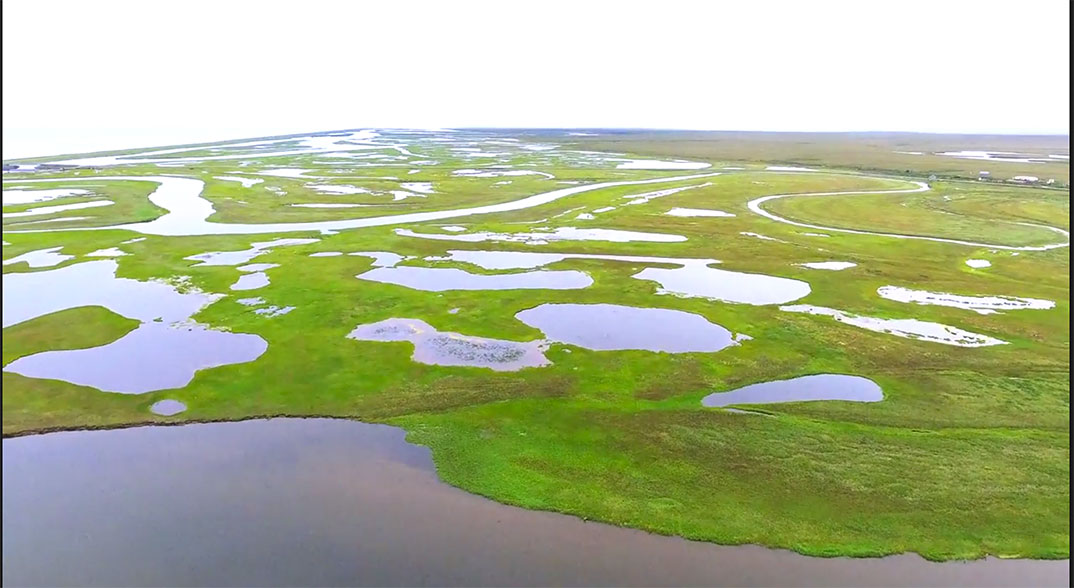
Kawerak Land Management Services advocates where needed for our Native Allotment owners. The permit area is surrounded by Native Allotments and the potential for tresspass. The Native Allotment owners have stressed over and over again that they oppose any mining activity or any activity that creates a disturbance in that area. These lands were selected long ago for the subsistence resources available. The natural migration of wildlife provides a food source and other life support systems upon which Allottee’s depend on. Further disturbance of the estuary will accelerate and promote the decline of subsistence resources. Climate change effects are happening, this area is full of living creatures, habitats that must be protected so that the food sources are not contaminated by toxic wastes on land, the sea, the rivers and lakes. This can diminish our ability to secure clean and healthy foods we depend on.
Mining at any time in an estuary is very problematic as the ecosystem is abundant with water flora, and all species of Arctic fish. Additionally, a large variety of birds are preparing to migrate south, teaching their young to fly. The August time frame in which IPOP is requesting to do core drilling and other sampling find all the salmon species present, plus an abundance of fresh water fish such as herring, grayling, white fish and trout, whose presence in the water is for feeding on the spawned eggs of salmon. Migratory birds are just fledging in the area.
One of IPOP’s statements, from their original application, was their intent to do an eel grass study and other made commitments. However, none of have taken place. Despite these failed commitments, they assume it will be ignored or forgotten. Because they are submitting an application from the same estuary, the fact that they have not completed the eel grass study or other commitments is all the more reason behind not permitting IPOP to do core sampling for their extended time in August. We recommend the agencies that have the decision making authority to review what was done last year by IPOP in the determination for future mining.
In IPOP’s application they are requesting to use the public boat ramp on the south west corner of Bonanza Bridge. The area may be within the State right of way, however, the area being requested for use is not a ‘boat ramp’ (there is no cement or wooden ramp or even compacted gravel). Other than the Council Highway, infrastructure is not maintained and all of the ground from the road leading to the channel is loose sand. The boat ramp is primarily used by subsistence users. Launching of any heavy vessels will require heavy vehicles and these will more than likely get mired and stuck in the process, ruining what stability there is from light usage of small boats/motor.
The area being requested for use is within the State right of way, in which we question whether the adjacent land owners have been notified of changes from light usage to commercial usage? AS 16.05.258 clearly states subsistence use is the #1 priority above all else. If IPOP is granted permission to launch vessels and park equipment in this area, this will clearly be setting precedence as a commercial use site despite the fact that subsistence users have relied upon the area since time immemorial.
IPOP claims they performed a turbidity plume study in May and they also state the turbidity immediately settled back to the bottom. Almost the entire Safety Sound/Bonanza Channel bottom is covered with a very sticky almost greasy-like substance which is very fine black mud. Just from walking in the area this mud is stirred up and released into the water column and it can linger for long periods afterwards. A drill rig or dredge to test turbidity levels will have a much greater impact. Where are the results of this plume study? Was an independent third party available to confirm and agree with these results? Has DNR received the results from the original test? Was the plume study even took place back in May? Eyewitness accounts expressed that if the so called plume study took place on May 31, they saw no vessels in the area.
IPOP claims there will be no significant effects during the coring survey if allowed to drill in August. Migrating/spawning salmon are still present during this timeframe, furthermore, ADF&G has data showing that salmon are still present well into October & November.
IPOP wants to perform additional core drilling. What are the results of the original core samples? Was a third party observer there to take control over the core samples and confirm the results? In a teleconference with Department of Natural Resources, Department of Environmental Conservation, ACE, Division of Habitat it was announced IPOP does not have to release the results until they submit the permit application. This would indeed be putting the cart way before the horse. If the core samples show no gold why proceed to the permitting process?
In IPOP’s amended application they state the coring project has been extremely scaled back and this will have less impact on fish. Mercury, lead or other contaminants are suspended in the water column, so how is this less of an impact? Any drilling will suspend any of these harmful contaminants that took hundreds if not thousands of years to settle to where they are now.
IPOP is wanting to conduct further drilling in their eastern claim blocks. They state in the amended application the eastern most claim blocks are particularly isolated. It would not be safe or economical to core in winter conditions when ice thickness on the Bonanza Channel would support the coring equipment. The eastern most location is over 110 miles roundtrip from Nome. The distance from emergency assistance would make the timely rescue of personnel impossible. The eastern claims location is far too remote. All of these statements are false. The eastern claim blocks are approximately 4-5 miles further east than the drilling that took place last April. One way travel to the Bonanza Bridge is approximately 30 miles from Nome making roundtrip 60 miles. All travel would also be on the State highway. IPOP claims winter travel would be unsafe in Bonanza Channel due to ice conditions and water running underneath in the eastern most claim block. These are the exact same conditions they encountered when they drilled back in April and the equipment was fully supported by the ice. The eastern claim blocks are no more remote than the claim blocks just to the west where drilling took place.
IPOP states there is no eel grass in the area. This is false. The entire area has eel grass. A third party needs to verify what is there and what is not, IPOP should not be allowed to make statements of what they believe to be true in hopes their information result in getting the permit requested.
The dates AFD&G has set aside for migrating/spawning are there for a reason, to protect salmon. Silver salmon have been documented migrating through by ADF&G well into October, even November. Any drilling taking place other than in the winter would literally stir up the bottom and immediately put out a turbidity plume that would extend a great distance and be suspended in the water column for an extended period of time. In this particular area the ½ mile really should be extended to 1 mile. The Safety Sound/Bonanza Channel area is unlike the ocean where there is usually a strong enough current or storm that repairs the bottom. The Bonanza Channel may never repair itself and the damage would remain for hundreds if not thousands of years.
In the permit application to extend data collection IPOP makes several contradictory statements. IPOP states they are not wanting to extend the plume study. However, IPOP further states they want ADF&G to grant another fish habitat permit to cover the study under the existing permit and to further the plume study in August.
IPOP claims that winter coring ruined $80,000 worth of equipment and that the distance from Nome would exceed the limitations of ice hauling machines and would require open carry of gasoline as the hauler is gas powered. They also claim winter travel would require them to go over Solomon River. This would imply they intend to drill up and in the Solomon River where they do not have mining claims according to the maps. There is absolutely no reason to cross any portion of the Solomon or Bonanza Rivers. IPOP has been given official written notice that trespass is not allowed. If travel occurs across Solomon Native Corporation owned lands, it would be a clear violation of their permit if the current request for extension is approved.
IPOP also states in their application that winter temperatures are far too dangerous to human life and they will not risk human life on the east side winter operations. In mid to late April winter temperatures are usually around 10 to 30 deg. F. a far cry from the -60 deg. F that IPOP claims in their permit application.
What has been made very clear is IPOP has proven they are very inexperienced in anything they have tried to perform. They claim that drilling on top of the ice is what ruined the pontoon they had the drill rig on. Our understanding is IPOP dragged the pontoon all the way from Nome to their claim blocks with no cargo sled underneath. This is more than likely the cause of the damage to the pontoons, operator error and inexperience, not because the drill rig/pontoon was placed on the ice.
In conclusion, Kawerak, Inc. opposes the extension for core drilling and turbidity testing proposed by IPOP for the project in Bonanza Channel.
Sincerely,
KAWERAK, INC.
Charlene Bringhurst
C/O Department of Natural Resources – Mining Section
550 West 7thAve.
Anchorage, AK 99501
[googlepdf url=”https://kawerak.org/wp-content/uploads/2019/08/IPOP-Comment-Letter.pdf” download=”Download” ]